

[ad_1]
- New research aims to draw attention to the way climate change is making hurricanes more dangerous.
- The current Saffir-Simpson Hurricane Wind Scale tops out at Category 5.
- It doesn’t account for storm surge and other risks.
A conversation popped up recently in one of our daily staff weather briefings:
Should a Category 6 be added to the Saffir-Simpson Hurricane Wind Scale, which currently tops out at Cat 5?
The discussion was brought on by new research from Michael Wehner and James Kossin, well-respected scientists in the field of extreme weather and climate change.
Their paper, published Monday in the journal PNAS, doesn’t propose any actual changes. It merely poses the idea as a way to draw attention to climate change and the ways it’s making strong hurricanes even more dangerous.
While the research is just for awareness, we sat down with our expert team of meteorologists from weather.com and The Weather Company to talk about the whole idea of Category 6 hurricanes, stronger storms and keeping people safe.

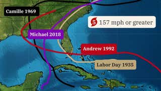
The Saffir-Simpson Hurricane Wind Scale includes five categories that predict a hurricane’s wind damage.
Adding to the Saffir-Simpson scale has been debated for years, with the point being made that there is a potential for storms much stronger than the 157 mph criteria that is the minimum definition of a Cat 5. Thoughts?
Linda Lam: One of the concerns I have with a Category 6 is that categories in general indicate wind speed and nothing about water hazards, which are typically the most important impact and the deadliest aspect of a tropical cyclone.
Chris Dolce: Setting apart the strongest Category 5 hurricanes into a separate Category 6 might be useful for scientists to track statistically in a warming world, but I’m not sure the public needs another layer to interpret. Category 5 rated hurricanes are described as producing catastrophic wind damage, which is already pretty dire wording for the public.
Jon Erdman: On one hand, there is an argument to be made that, for example, 215 mph Hurricane Patricia in 2015 seemed to have been in another realm from a 160 mph Cat. 5. However, as Chris pointed out, the NHC describes Cat. 5 wind damage as “catastrophic.” So, what would Cat. 6 wind damage be? How do you get more damaging than “catastrophic?”
(MORE: Not Just The Category: 2 Other Things You Should Know About Hurricanes and Tropical Storms)
Jonathan Belles: One worry I have with this is that we’ll be focusing even more energy on wind speeds, while rainfall flooding can cause deaths thousands of miles away from the coast where no category is attached. Look at 2021’s Ida. Many of the fatalities and much of the damage were in the Northeast and well removed from when the storm was a Category 4 along the Louisiana coastline.
Briana Waxman: The other mets summed up my thoughts very well! The only thing I would add is my strong opinion that we should scrap the current scale and re-do it with hazards/impacts in mind rather than just add another category to an already flawed measurement system.
Peter Neilley: The inclusion of a new Category 6 in the Saffir-Simpson scale is needed and appropriate given the fact that the winds in tropical cyclones can and are becoming more intense in a changing climate. However, it’s important to reiterate that as individual storms threaten, there are many other factors besides hurricane category that will strongly influence the impact a storm has on you, and one needs to pay attention to all these factors. These other factors include precise storm path relative to you, storm surge and surf heights, total rainfall expected and inland stream and river flooding potential, and the threat of embedded tornadoes.
(MORE: Is There A Difference Between A Super Typhoon And A Hurricane?)
Danielle Banks: The beauty of studies like the one by Wehner and Kossin is that whether you agree or disagree with these concepts, they spark much needed conversations in the meteorological community. At the end of the day, every scientist who is weighing in, no matter what their specialty, is giving their opinion because they deeply care about saving lives and want to put out the best messaging possible in order to help people make better decisions.
Kait Parker: The authors of the recent study achieved their goal of sparking a conversation on how we look at storms of the future. We know climate change is pushing our new strongest storms to be even stronger but focusing on the Saffir-Simpson scale neglects the tremendous list of worsening impacts.

The National Hurricane Center weighed in on Tuesday, saying there are no plans to add Category 6, in part because the scale isn’t a very effective tool. But what changes do need to be made in terms of messaging to the public, especially as climate change ramps up the danger for millions of people both along coastlines and far inland?
Dolce: What’s sorely needed from a communication standpoint are improvements in how we convey the various dangers hurricanes pose, not just from wind, but equally as important are their storm surge and flooding rainfall threats.
(MORE: Why the Projected Path For Hurricanes, Tropical Storms Doesn’t Always Tell the Full Story)
Belles: We need to incorporate storm surge and rainfall flooding threats into our messaging as best we can. Water threats make up the vast majority of fatalities in this country and those threats are worsening in a warmer world. As social scientists and meteorologists, the tall task that we have ahead of us is to mush all of this into a one-to-five scale. An attempt at this was made in the 2000s based on wind speeds and the size of a hurricane, which is a proxy for likely storm surge. That scale was called the Integrated Kinetic Energy scale. But its fatal flaw was that it was more difficult to calculate and harder to communicate.
Neilley: [Threats besides wind] can vary widely from storm to storm, and may not be well correlated with storm category, so it is important to know and consider all of them as one prepares for an impending storm.

A crew member onboard the International Space Station took this photograph of Hurricane Ian on Sept. 26, 2022, while orbiting more than 250 miles above Earth’s surface. Ian underwent rapid intensification, something scientists say is happening more often due to climate change.
(NASA Earth Observatory)
What could be some direct repercussions of adding a Category 6?
Lam: I also fear that if there is a Category 6 that people will take lower categories, like a Category 3, less seriously. We try to emphasize impacts over category in our messaging and that is a challenge since the easy category number is often a focus instead of the specific details of what to expect.
Dina Knightly: If a Category 6 was added, I feel like there may be more confusion about what category means what. As meteorologists, we know what to expect with classifications, but most people are used to a certain scale. To alter that may confuse people and we may lose the urgency of our message.
Dolce: Categories sometimes don’t illustrate to the public the full story when it comes to impacts. An example in the past that comes to mind is Hurricane Ike in 2008, which had Category 2 winds on approach to Texas, but because it was so large in size it produced a massive, devastating storm surge along the Bolivar Peninsula. Florence in 2018 and Matthew in 2016 come to mind as recent hurricanes that made landfall at Category 1 wind strength, but both produced massive rainfall flooding in the Carolinas.
(MORE: Hurricane Season Terms You Need to Know)
Belles: I don’t think we can say this enough: Adding a new category adds new focus to just one hazard that hurricanes bring, and a very rare echelon of hurricanes at that.
Erdman: I don’t think it would matter in the grand scheme of communication to the public. A Cat. 5 hurricane’s winds are already life-threatening and devastating if they occur at landfall. And, as others mentioned, slower-moving tropical depressions or storms may have much weaker winds, but could have “Category 5 or 6 rainfall flood potential.” Tropical Storm Allison, and its remnant, in 2001 was the poster child for that.

IN FLIGHT- AUGUST 30: A US Coast Guard helicopter passes over a flooded neighborhood east of downtown New Orleans August 30, 2005 in flight over Louisiana. Approximately 100 people are feared dead and estimates put the property loss at nearly $30 billion as Hurricane Katrina could become the costliest storm in US history. It is estimated that 80 percent of New Orleans is under flood waters as levees begin to break and leak around Lake Ponchartrain.
(Photo by Dave Einsel/Getty Images)
We know that climate change is fueling stronger hurricanes, more coastal flooding and erosion and spreading impacts further inland. What does this mean for our future?
Erdman: Have you noticed the number of “rapidly intensifying” storms in recent years? The underforecasted nightmare scenario of Hurricane Otis last October in Acapulco, Mexico, was only the latest example. With global ocean temperatures smashing records last year – including the tropical Atlantic Basin – that’s an unsettling sign for future tropical cyclone potential to both rapidly strengthen and become intense more often.
Parker: Yes, our maximum sustained winds may be topping out higher than we may have expected decades ago. But we also have unprecedented rainfall in tropical systems including ones that may not even be designated a hurricane, storm surge that reaches farther inland due to sea level rise and rapid intensification that is becoming increasingly common. Like Briana suggested, perhaps we need an entirely new way of categorizing the risks of tropical cyclones and forget Saffir-Simpson altogether.
Weather.com reporter Jan Childs covers breaking news and features related to weather, space, climate change, the environment and everything in between.
The Weather Company’s primary journalistic mission is to report on breaking weather news, the environment and the importance of science to our lives.
[ad_2]
Source link